top of page
MAI Logo WebHeader 3.png

Terrain Algorithms and Products

Core Products


The following windows detail the Precision Terrain digital surface model (DSM) product that Anthony developed while at Lockheed Martin.  

​

Digital Surface Models

Rihyad-DSM.jpg

The Precision Terrain digital surface model (DSM) product is a high resolution sub-meter raster elevation model generated from pairs of commercial satellite images.

​

Digital Terrain Models

Rihyad-DTM.jpg

The digital terrain model (DTM) is an extension of the Precision Terrain DSM that removes all surface topography and creates a "bare-earth" elevation model.

​

Areal Rendering

ArealRender1.jpg

Areal rendering augments a DSM or DTM product using areals (area-based polygons) of building locations to artificially insert buildings into the surface model.

​

Areal Sharpening

coming-soon_edited.jpg

Areal sharpening is the process of using areals of building locations to refine building footprints that are automatically derived while generating the DSM.

​

Road Smoothing

RoadFlatten.jpg

Road smoothing uses areals or vector-based polylines to define the locations of roads in the DSM.  This algorithm then flattens and smooths the road surfaces to better simulation actual road conditions in the DSM.

​

Water Flattening

WaterFlatten.jpg

Water flattening uses areals from open sources to define the littoral boundaries of any significant bodies of water in the DSM and flatten them to a uniform elevation.

​

​

Epipolar Rectification

Epipolar1.jpg

Epipolar rectification is the process of aligning two images such that vertical relief presents the image pair presents itself in the horizontal direction of the image.  Epipolar rectified images can be viewed in 3D with the appropriate hardware.

​

Disparity Mapping

Disparity_01_Pan.jpg

A disparity map is a pixel-by-pixel map of offset between two epipolar images.  The disparity map is the basis of the Digital Surface Model.

​

​

​

Anaglyph / Stereoscopic Imagery

Anaglyph(4,4)_Small.jpg

A pair of epipolar rectified images can be combined to make a red-cyan analglyph image that can be used to visually see vertical relief.

​

​

​

​

Advanced Terrain Analysis

The following algorithms and products depict some of the analysis algorithms that can be generated using this Precision Terrain or comparable DSM products.  These may also be used with higher resolution products like LiDAR.

​

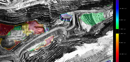
3D Change Detection

Pit4_4_ChangeMap.jpg

Pairs of DSM surfaces are registered and compared to detect local changes in the topography.  These changes can also be used to calculate the local volumetric differences at each change site.

​

Viewshed

Viewshed.jpg

The viewshed algorithm determines the geographic locations that are visible from a given point in the scene.

​

​

​

Flood Mapping

FloodMap.jpg

The flood mapping algorithm simulates rising water in an area based on the DSM.  This shows the potential flooding caused by rising water.

​

​

​

Slope Analysis

RedX.png

This algorithm evaluates the profile of the DSM to indicate the steepness of slopes in the geographic area.  This information can be used for tasks such as evaluating terrain traversal, probability of avalanche, or levy collapse.

​

More Info

Relative Height Mapping

RelativeTerrainHeight.jpg

This algorithm provides a visual metric for iso-elevation contours throughout a geographic area.  This information can be used to assess potential terrain collision for airborne systems.

​

Terrain Collision Avoidance

VerticalObstructionMap.jpg

This algorithm provides a visual metric for iso-elevation contours throughout a geographic area.  This information can be used to assess potential terrain collision for airborne systems.

​

bottom of page